It's looking more and more like a blast of winter will hit southeast Wyoming on Thanksgiving Day, with cold weather continuing right into the weekend.

That's according to the Cheyenne Office of the National Weather Service. The agency posted the following on its website:


Widespread minor winter impacts becoming more likely (>70% chance) starting late Thanksgiving evening and especially through the day Friday. 20-30% of moderate winter impacts in select pockets as well. Winter weather impacts anticipated to increase Friday morning to the afternoon based on current projections. Stay tuned through the week if these areas expand or impact chances increase/decrease. Plan accordingly on Friday if planning any travel post Thanksgiving.

Parts of southeast Wyoming could get as much as 8 inches of snow:

A Winter Storm Watch is in effect from 11 AM Thursday to 11 PM Friday for the highlighted locations, including Bill, Douglas, Deer Creek, Glenrock, Lusk, Redbird, Bordeaux, Wheatland, Guernsey and Torrington. Heavy snow will be possible with total snowfall accumulations of 4 to 8 inches possible. The Winter Storm Watch may be expanded to other areas. Travel may be difficult at times.

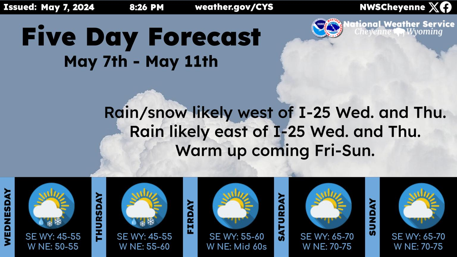
Here is the forecast for Cheyenne:

Today
Sunny, with a high near 51. Northwest wind 10 to 15 mph.
Tonight
Mostly clear, with a low around 30. West wind around 10 mph.
Wednesday
Sunny, with a high near 64. West wind 10 to 15 mph.
Wednesday Night
Partly cloudy, with a low around 24. Northwest wind around 5 mph.
Thanksgiving Day
A chance of sprinkles and flurries before 2pm, then a chance of sprinkles between 2pm and 3pm, then a chance of flurries after 3pm. Mostly cloudy, with a high near 38. Southeast wind 5 to 15 mph.
Thursday Night
Snow showers. Low around 9. Chance of precipitation is 90%.
Friday
Snow showers, mainly before 11am. High near 19. Chance of precipitation is 90%.
Friday Night
A chance of snow showers, mainly before 11pm. Mostly cloudy, with a low around 4.
Saturday
Mostly sunny, with a high near 27.
Saturday Night
Mostly clear, with a low around 9.
Sunday
Sunny, with a high near 36.
Sunday Night
Mostly clear, with a low around 9.
Monday
Sunny, with a high near 39.
Here is the Laramie Forecast:
Today
Sunny, with a high near 44. West northwest wind 5 to 15 mph.
Tonight
Mostly clear, with a steady temperature around 29. West wind around 10 mph becoming south southwest in the evening.
Wednesday
Sunny, with a high near 55. West southwest wind 10 to 15 mph.
Wednesday Night
Partly cloudy, with a low around 26. Southwest wind 5 to 10 mph.
Thanksgiving Day
A 20 percent chance of snow showers after 11am. Mostly cloudy, with a high near 36. Southeast wind 10 to 15 mph, with gusts as high as 25 mph.
Thursday Night
Snow showers. Low around 10. Chance of precipitation is 90%.
Friday
Snow showers, mainly before 11am. High near 16. Chance of precipitation is 80%.
Friday Night
A chance of snow showers, mainly before 11pm. Mostly cloudy, with a low around 3.
Saturday
Mostly sunny, with a high near 21.
Saturday Night
Mostly clear, with a low around 5.
Sunday
Sunny, with a high near 29.
Sunday Night
Mostly clear, with a low around 6.
Monday
Sunny, with a high near 34.

Wyoming National Guard at UW for Military Appreciation Week

November 2023

Gallery Credit: Photos by Wyoming National Guard


More From Laramie Live