
Cheyenne Could Get 11 Inches Of Snow, 6-10 For Laramie
UPDATE: As of early Tuesday afternoon, the Cheyenne Office of the National Weather Service said it had officially recorded 6 inches of snow, with more expected.
Original Article:The Cheyenne Office of the National Weather Service has now expanded the area of southeast Wyoming covered by a Winter Storm Warning to include Laramie as well as Cheyenne.
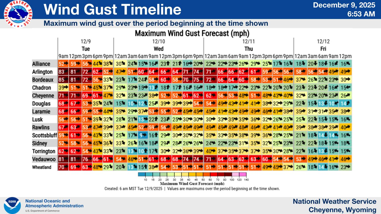
Here are the latest snowfall projections from the agency:
It also looks like we can expect snow to continue well into Wednesday

Here is more information:
Cheyenne, Laramie Forecasts
Cheyenne Forecast
Today
Snow. Some thunder is also possible. High near 34. East northeast wind 10 to 15 mph. Chance of precipitation is 100%. Total daytime snow accumulation of 2 to 4 inches possible.
Tonight
Snow. Low around 24. Northeast wind 10 to 15 mph. Chance of precipitation is 90%. New snow accumulation of 3 to 5 inches possible.
Wednesday
Snow, mainly before noon. Some thunder is also possible. High near 34. North northeast wind 10 to 15 mph becoming west northwest in the afternoon. Chance of precipitation is 80%. New snow accumulation of around an inch possible.
Wednesday Night
Mostly clear, with a low around 20. West wind 10 to 15 mph, with gusts as high as 25 mph.
Thursday
Sunny, with a high near 57. Breezy, with a west wind 20 to 25 mph, with gusts as high as 40 mph.
Thursday Night
A chance of showers and thunderstorms. Mostly cloudy, with a low around 35. Breezy. Chance of precipitation is 40%.
Friday
A 30 percent chance of showers and thunderstorms after noon. Mostly sunny, with a high near 65. Breezy.
Friday Night
Mostly cloudy, with a low around 40.
Saturday
A slight chance of showers, then showers likely and possibly a thunderstorm after noon. Mostly sunny, with a high near 66. Breezy.
Saturday Night
A chance of showers and thunderstorms. Mostly cloudy, with a low around 33. Breezy.
Sunday
A chance of showers and thunderstorms. Mostly sunny, with a high near 62.
Sunday Night
Partly cloudy, with a low around 37.
Monday
Sunny, with a high near 74.
Laramie Forecast
Today
Snow. Some thunder is also possible. High near 33. East wind 10 to 15 mph. Chance of precipitation is 100%. Total daytime snow accumulation of 1 to 2 inches possible.
Tonight
Snow. Low around 22. Northeast wind 10 to 15 mph. Chance of precipitation is 90%. New snow accumulation of 1 to 3 inches possible.
Wednesday
Snow likely, mainly before noon. Cloudy, then gradually becoming mostly sunny, with a high near 32. North northeast wind around 10 mph becoming northwest in the afternoon. Chance of precipitation is 70%. New snow accumulation of less than one inch possible.
Wednesday Night
Mostly clear, with a low around 16. West northwest wind 10 to 15 mph becoming southwest in the evening.
Thursday
Mostly sunny, with a high near 52. Breezy, with a west wind 15 to 20 mph, with gusts as high as 30 mph.
Thursday Night
A chance of showers and thunderstorms. Mostly cloudy, with a low around 35. Breezy. Chance of precipitation is 40%.
Friday
A 30 percent chance of showers and thunderstorms after noon. Partly sunny, with a high near 61. Breezy.
Friday Night
Mostly cloudy, with a low around 40.
Saturday
A slight chance of showers, then showers likely and possibly a thunderstorm after noon. Mostly sunny, with a high near 60. Breezy.
Saturday Night
A chance of showers and thunderstorms. Mostly cloudy, with a low around 33. Breezy.
Sunday
A chance of showers and thunderstorms. Partly sunny, with a high near 58.
Sunday Night
Partly cloudy, with a low around 36.
Monday
Sunny, with a high near 69. Breezy.
Medicine Bow Wyoming Road Art
There’s a strange mind at work in Medicine Bow. Someone equal parts disturbed and delighted, scheming and laughing at the same time. And somehow, they want to pull you into the fun.
Gallery Credit: Glenn Woods