A High Wind Warning has been issued for much of southeast Wyoming starting later today, with snow also possible at least through Friday.

That's according to the Cheyenne Office of the National Weather Service.

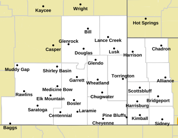
A High Wind Warning is in effect starting at 3 p.m. today. The watch area includes Cheyenne, but at last report, stopped just outside of Laramie. A cold front expected to pass through the region will also bring snow.

The map below shows the area included in the High Wind Warning, in light yellow:

Map of Forecast Area


Snow Also Is Expected

⛈️ Showers and thunderstorms developing Monday PM, mainly over the High Plains, will have the potential to produce gusty winds and/or hail. A Marginal risk (Level 1 of 5) for severe thunderstorms is in place for Monday.

❄️ Further west, crashing temperatures behind the cold front will allow snow to mix in. Impacts due to accumulating snow are possible in the mountains and in the Laramie Valley. The graphic shows areas with a moderate or high probability of 2+" of snow in orange and red respectively.

(Left) probability of 2+" of snow Monday night into Tuesday. (Right) Storm Prediction Center risk for severe thunderstorms on Monday

Cheyenne And Laramie Forecast


Cheyenne Forecast

High Wind Warning In Effect Starting At 3 p.m. Today

Today
A 40 percent chance of showers, mainly after 3pm. Mostly sunny, with a high near 68. Windy, with a northwest wind 10 to 20 mph becoming west 20 to 30 mph in the afternoon. Winds could gust as high as 40 mph.
Tonight
Showers likely, mainly after 3am. Mostly cloudy, with a low around 39. Windy, with a northwest wind 30 to 35 mph, with gusts as high as 50 mph. Chance of precipitation is 60%. New precipitation amounts between a tenth and quarter of an inch possible.
Tuesday
Showers, mainly before noon. High near 57. Windy, with a northwest wind 30 to 40 mph, with gusts as high as 60 mph. Chance of precipitation is 90%.
Tuesday Night
Partly cloudy, with a low around 35. Breezy, with a northwest wind 20 to 25 mph decreasing to 10 to 15 mph in the evening. Winds could gust as high as 40 mph.
Wednesday
A 50 percent chance of showers after noon. Partly sunny, with a high near 59. Breezy, with a west wind 10 to 15 mph increasing to 15 to 20 mph in the afternoon. Winds could gust as high as 30 mph.
Wednesday Night
Rain showers before 9pm, then rain and snow showers between 9pm and 10pm, then snow showers after 10pm. Low around 26. Blustery. Chance of precipitation is 80%.
Thursday
A 50 percent chance of snow showers. Mostly cloudy, with a high near 39.
Thursday Night
A chance of snow showers. Mostly cloudy, with a low around 26.
Friday
Snow showers likely, mainly after noon. Mostly cloudy, with a high near 40.
Friday Night
Snow showers likely. Mostly cloudy, with a low around 25.
Laramie Forecast
Today
Showers likely, mainly after 4pm. Increasing clouds, with a high near 60. Breezy, with a west southwest wind 5 to 10 mph becoming northwest 15 to 20 mph in the afternoon. Winds could gust as high as 30 mph. Chance of precipitation is 60%. New precipitation amounts of less than a tenth of an inch possible.
Tonight
Rain showers likely before 7pm, then rain and snow showers. Some thunder is also possible. Low around 32. Windy, with a west northwest wind 15 to 20 mph increasing to 25 to 30 mph after midnight. Winds could gust as high as 40 mph. Chance of precipitation is 90%. New snow accumulation of less than a half inch possible.
Tuesday
Rain and snow showers, becoming all rain after 11am. High near 52. Windy, with a northwest wind 25 to 30 mph, with gusts as high as 50 mph. Chance of precipitation is 90%. New snow accumulation of less than a half inch possible.
Tuesday Night
A 20 percent chance of showers before 7pm. Partly cloudy, with a low around 31. Blustery, with a west wind 20 to 25 mph decreasing to 10 to 15 mph after midnight. Winds could gust as high as 35 mph.
Wednesday
A slight chance of snow showers between 7am and 11am, then a chance of rain showers. Partly sunny, with a high near 53. Breezy, with a west southwest wind 10 to 15 mph increasing to 20 to 25 mph in the afternoon. Winds could gust as high as 30 mph. Chance of precipitation is 50%.
Wednesday Night
Rain showers before 9pm, then snow showers. Low around 25. Blustery. Chance of precipitation is 80%.
Thursday
Snow showers likely, mainly before 7am. Partly sunny, with a high near 41. Chance of precipitation is 70%.
Thursday Night
A chance of snow showers. Mostly cloudy, with a low around 25.
Friday
A chance of snow showers. Mostly cloudy, with a high near 42.
Friday Night
Snow showers likely, mainly between 7pm and 1am. Cloudy, with a low around 25.
Saturday
A chance of snow showers. Mostly cloudy, with a high near 43.
Saturday Night
A chance of snow showers. Mostly cloudy, with a low around 26.
Sunday
A slight chance of showers. Mostly sunny, with a high near 57.

Check Out the Damages from Cheyenne's Wild Spring Wind Storm

On April 6 and 7, 2024, wild winds exceeding 90 mph blew through SE Wyoming, causing havoc in Cheyenne and on the interstate. Everything from fences to semis were upturned in the wind storm. Check out the damage shared by residents below.

Gallery Credit: Doug Randall

More From Laramie Live