Hurricane-Force Wind to Blast Southeast Wyoming Through Wednesday
Wind gusts of 70 to 80 mph are expected to blast much of southeast Wyoming today through Wednesday, the National Weather Service in Cheyenne says.
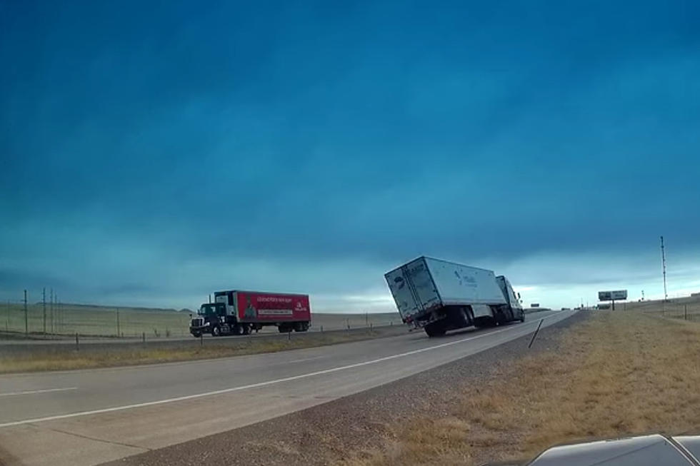
A High Wind Warning is currently in effect through 9 p.m. Tuesday for much of southeast Wyoming, including Cheyenne and Laramie, with gusts up to 70 mph expected.

A High Wind Warning also remains in effect until 6 p.m. Wednesday for the wind-prone areas, including Interstate 80 near Arlington and the Summit and Interstate 25 near Bordeaux, with gusts of 70 to 80 mph expected.
URGENT - WEATHER MESSAGE
National Weather Service Cheyenne WY
558 AM MDT Mon May 6 2024

WYZ103>105-107>109-115-117>119-070000-
/O.CON.KCYS.HW.W.0023.240506T1400Z-240508T0300Z/
North Laramie Range-Ferris/Seminoe/Shirley Mountains-Shirley
Basin-East Platte County-Goshen County-Central Carbon County-
Laramie Valley-South Laramie Range Foothills-Central Laramie
County-East Laramie County-
Including the cities of Laramie, Wheatland, Whitaker, Medicine
Bow, Cheyenne, Garrett, Torrington, Horse Creek, Bosler, Federal,
Shirley Basin, Pine Bluffs, Rawlins, Guernsey, and Seminoe Dam
558 AM MDT Mon May 6 2024

...HIGH WIND WARNING REMAINS IN EFFECT UNTIL 9 PM MDT TUESDAY...

* WHAT...West winds 35 to 45 mph with gusts up to 70 mph expected.

* WHERE...Much of southeast Wyoming including Cheyenne, Laramie,
  Wheatland, Rawlins, and Torrington. This also includes Interstate
  25 from Cheyenne to Glendo.

* WHEN...Until 9 PM MDT Tuesday.

* IMPACTS...Mainly to transportation. Strong cross winds will be
  hazardous to light weight or high profile vehicles, including
  campers and tractor trailers.

* ADDITIONAL DETAILS...Strongest winds are expected Monday with
  elevated to strong winds lingering through Tuesday.

PRECAUTIONARY/PREPAREDNESS ACTIONS...

A High Wind Warning means a hazardous high wind event is expected or
occurring. Sustained wind speeds of at least 40 MPH or gusts of 58
MPH or stronger can lead to property damage.
URGENT - WEATHER MESSAGE
National Weather Service Cheyenne WY
558 AM MDT Mon May 6 2024

WYZ106-110-116-070000-
/O.CON.KCYS.HW.W.0022.000000T0000Z-240509T0000Z/
Central Laramie Range and Southwest Platte County-North Snowy
Range Foothills-South Laramie Range-
Including the cities of Buford, Arlington, Elk Mountain, Pumpkin
Vine, Vedauwoo, and Bordeaux
558 AM MDT Mon May 6 2024

...HIGH WIND WARNING REMAINS IN EFFECT UNTIL 6 PM MDT WEDNESDAY...

* WHAT...West winds 35 to 50 mph with gusts of 70 to 80 mph expected.

* WHERE...Southeast Wyoming wind-prone areas including Interstate 80
  near Arlington and the Summit and Interstate 25 near Bordeaux.

* WHEN...Until 6 PM MDT Wednesday.

* IMPACTS...Mainly to transportation. Strong cross winds will be
  hazardous to light weight or high profile vehicles, including
  campers and tractor trailers. There will be a high risk for
  vehicle blow overs, particularly along north to south oriented
  roadways.

* ADDITIONAL DETAILS...Strongest winds are expected Monday with
  elevated to strong winds lingering through Wednesday.

PRECAUTIONARY/PREPAREDNESS ACTIONS...

A High Wind Watch means there is the potential for a hazardous high
wind event. Sustained wind speeds of at least 40 MPH or gusts of 58
MPH or stronger may occur. Continue to monitor the latest forecasts.

Fasten loose objects or shelter objects in a safe location prior to
the onset of winds.
As of 10:46 a.m., Interstate 25 between the Colorado state line and Wheatland and Interstate 80 between Rawlins and Cheyenne were closed to light, high-profile vehicles due to extreme blowover risk.

High Wind Warnings are in effect for Scotts Bluff, Banner and Kimball Counties in the Nebraska Panhandle until 6 AM Tuesday. High Wind Warnings for Arlington, Bordeaux and the I-80 Summit until 6 PM Wednesday. High Wind Warnings for much of southeast Wyoming until 9 PM Tuesday including Cheyenne, Laramie, Wheatland, Torrington and Rawlins. Gusts of 60 to 80 mph will be likely.
Check Out the Damages from Cheyenne's Wild Spring Wind Storm
Gallery Credit: Doug Randall
More From Laramie Live

