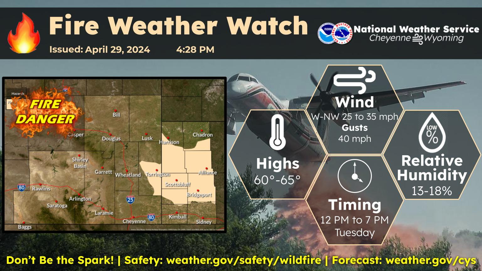
The Cheyenne Office of the National Weather Service says severe storms featuring large hail, strong winds, and a tornado or two are possible in southeast Wyoming and the Nebraska.

The greatest danger of severe weather is east of Interstate 25, according to the agency. The weather service posted the following on it's website:

 A Slight Risk Area has been identified by the Storm Prediction Center, for areas east of Interstate 25 into the Nebraska Panhandle this afternoon and evening. All modes of severe weather are possible, including large hail, damaging downburst winds and possibly a tornado or two. Keep an eye on the sky today and have a way to receive warnings when they are sent out. Timing wise, it looks like storms will really begin intensifying after 2PM, peaking out by early evening. Be safe!

Here is the forecast for Cheyenne:

Today
A slight chance of showers and thunderstorms between noon and 3pm, then showers likely and possibly a thunderstorm after 3pm. Some of the storms could produce small hail and gusty winds. Patchy fog before 8am. Otherwise, partly sunny, with a high near 71. Breezy, with a south southeast wind 10 to 15 mph increasing to 15 to 20 mph in the afternoon. Winds could gust as high as 30 mph. Chance of precipitation is 70%. New rainfall amounts between a tenth and quarter of an inch, except higher amounts possible in thunderstorms.
Tonight
A 50 percent chance of showers and thunderstorms before midnight. Some of the storms could produce small hail and gusty winds. Mostly cloudy, with a low around 49. Breezy, with a south wind 10 to 20 mph.
Saturday
A 50 percent chance of showers and thunderstorms after noon. Mostly sunny, with a high near 72. South southeast wind 10 to 15 mph.
Saturday Night
A 40 percent chance of showers and thunderstorms before midnight. Partly cloudy, with a low around 45. South wind 5 to 15 mph becoming north in the evening.
Sunday
Showers likely and possibly a thunderstorm after noon. Partly sunny, with a high near 69. West wind 5 to 10 mph becoming south in the afternoon. Chance of precipitation is 60%.
Sunday Night
A 30 percent chance of showers and thunderstorms before midnight. Partly cloudy, with a low around 47.
Memorial Day
Showers likely and possibly a thunderstorm after noon. Partly sunny, with a high near 75. Chance of precipitation is 60%.
Monday Night
Mostly cloudy, with a low around 48.
Tuesday
A chance of showers and thunderstorms after noon. Partly sunny, with a high near 75.
Tuesday Night
A slight chance of showers and thunderstorms before midnight. Mostly cloudy, with a low around 48.
Wednesday
Showers likely and possibly a thunderstorm. Partly sunny, with a high near 72.
Wednesday Night
A chance of showers and thunderstorms. Mostly cloudy, with a low around 48.
Thursday
Showers likely and possibly a thunderstorm. Mostly cloudy, with a high near 71.
Here is the forecast for Laramie:
Today
Showers likely and possibly a thunderstorm after noon. Some of the storms could produce small hail and gusty winds. Increasing clouds, with a high near 67. Breezy, with a south southeast wind 10 to 15 mph increasing to 15 to 20 mph in the afternoon. Winds could gust as high as 30 mph. Chance of precipitation is 70%. New rainfall amounts of less than a tenth of an inch, except higher amounts possible in thunderstorms.
Tonight
A 40 percent chance of showers and thunderstorms before midnight. Some of the storms could produce small hail and gusty winds. Mostly cloudy, then gradually becoming mostly clear, with a low around 46. South wind around 15 mph, with gusts as high as 25 mph.
Saturday
Showers likely and possibly a thunderstorm after noon. Mostly sunny, with a high near 67. South wind 10 to 15 mph. Chance of precipitation is 70%.
Saturday Night
A 30 percent chance of showers and thunderstorms before midnight. Partly cloudy, with a low around 44. West southwest wind 5 to 10 mph.
Sunday
Showers likely and possibly a thunderstorm after noon. Partly sunny, with a high near 65. West wind 5 to 10 mph becoming south in the afternoon. Chance of precipitation is 60%.
Sunday Night
A 20 percent chance of showers and thunderstorms before midnight. Partly cloudy, with a low around 47.
Memorial Day
Showers likely and possibly a thunderstorm after noon. Mostly sunny, with a high near 69. Chance of precipitation is 70%.
Monday Night
Partly cloudy, with a low around 48.
Tuesday
Showers likely and possibly a thunderstorm after noon. Partly sunny, with a high near 69.
Tuesday Night
A slight chance of showers and thunderstorms before midnight. Mostly cloudy, with a low around 47.
Wednesday
Showers and possibly a thunderstorm. Partly sunny, with a high near 68.
Wednesday Night
A chance of showers and thunderstorms. Mostly cloudy, with a low around 47.
Thursday
Showers likely and possibly a thunderstorm. Mostly cloudy, with a high near 66.

Weird Foods That You May (or Probably Won't) Try

More From Laramie Live