Hurricane-Force Gusts to Blast Southeast Wyoming Today-Wednesday
Southeast Wyoming is no stranger to the wind, but today and Wednesday are going to blow, literally.
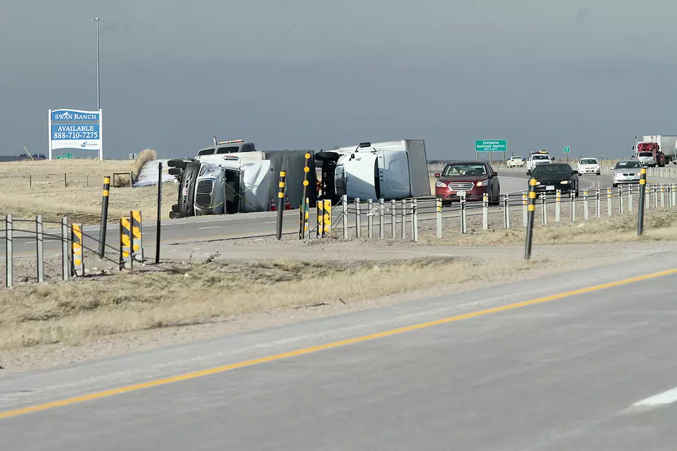
According to the National Weather Service in Cheyenne, much of Interstate 25 and Interstate 80 between Laramie and Cheyenne will see west winds of 35 to 50 mph with frequent gusts up to 75 mph and occasional gusts in excess of 80 mph.
Just to put that in perspective, a Category 1 hurricane has winds of 74 to 95 mph.
High Wind Warnings are in effect from 11 a.m. this morning through 3 p.m. Wednesday for the central Laramie Range and eastern Platte County, the southern Laramie Range and adjacent foothills, the lower elevations of Converse and Niobrara counties, and the north Snowy Range foothills.
A High Wind Warning is also in effect from 11 a.m. this morning to 9 p.m. this evening for the lower elevations of Carbon and Albany counties.
URGENT - WEATHER MESSAGE
National Weather Service Cheyenne WY
319 AM MDT Tue Apr 18 2023

WYZ106-107-116>118-190000-
/O.UPG.KCYS.HW.A.0037.230418T2100Z-230419T2100Z/
/O.NEW.KCYS.HW.W.0033.230418T1700Z-230419T2100Z/
Central Laramie Range and Southwest Platte County-
East Platte County-South Laramie Range-
South Laramie Range Foothills-Central Laramie County-
Including the cities of Bordeaux, Wheatland, Guernsey, Buford,
Pumpkin Vine, Vedauwoo, Whitaker, Federal, Horse Creek,
and Cheyenne
319 AM MDT Tue Apr 18 2023

...HIGH WIND WARNING IN EFFECT FROM 11 AM THIS MORNING TO 3 PM
MDT WEDNESDAY...

* WHAT...West winds 35 to 50 MPH with frequent gusts up to 75 MPH
  expected. Wind gusts may occasionally exceed 80 MPH.

* WHERE...Central Laramie Range and eastern Platte County
  including Glendo, Wheatland, Chugwater, and the Bordeaux
  Interchange along Interstate 25. Southern Laramie Range and
  adjacent Foothills including Interstate 80 between Laramie and
  Cheyenne.

* WHEN...11 AM MDT this morning until 3 PM MDT Wednesday. Brief
  periods of strong winds will be possible this afternoon and
  early evening due to showers and thunderstorms. A more intense
  period of strong winds will develop overnight into early
  Wednesday.

* IMPACTS...Mainly to transportation. Strong cross winds will be
  hazardous to light weight or high profile vehicles, including
  campers and tractor trailers.

PRECAUTIONARY/PREPAREDNESS ACTIONS...

A High Wind Warning means a hazardous high wind event is expected
or occurring. Sustained wind speeds of at least 40 mph or gusts of
58 mph or more can lead to property damage.
URGENT - WEATHER MESSAGE
National Weather Service Cheyenne WY
319 AM MDT Tue Apr 18 2023

WYZ101-102-190000-
/O.NEW.KCYS.HW.W.0033.230418T1700Z-230419T2100Z/
Converse County Lower Elevations-Niobrara County-
Including the cities of Douglas, Glenrock, Bill, Deer Creek,
Lusk, and Redbird
319 AM MDT Tue Apr 18 2023

...HIGH WIND WARNING IN EFFECT FROM 11 AM THIS MORNING TO 3 PM
MDT WEDNESDAY...

* WHAT...West to southwest winds 35 to 45 MPH with gusts up to 65
  MPH expected.

* WHERE...Lower elevations of Converse and Niobrara counties
  including Douglas, Bill, and Lusk.

* WHEN...11 AM MDT this morning until 3 PM MDT Wednesday. Brief
  periods of strong winds will be possible this afternoon and
  early evening due to showers and thunderstorms. A more
  persistent period of strong winds will develop overnight into
  early Wednesday.

* IMPACTS...Mainly to transportation. Strong cross winds will be
  hazardous to light weight or high profile vehicles, including
  campers and tractor trailers

PRECAUTIONARY/PREPAREDNESS ACTIONS...

A High Wind Warning means a hazardous high wind event is expected
or occurring. Sustained wind speeds of at least 40 mph or gusts of
58 mph or more can lead to property damage.
URGENT - WEATHER MESSAGE
National Weather Service Cheyenne WY
319 AM MDT Tue Apr 18 2023

WYZ110-190000-
/O.UPG.KCYS.HW.A.0037.230418T2100Z-230419T2100Z/
/O.NEW.KCYS.HW.W.0033.230418T1700Z-230419T2100Z/
North Snowy Range Foothills-
Including the cities of Arlington and Elk Mountain
319 AM MDT Tue Apr 18 2023

...HIGH WIND WARNING IN EFFECT FROM 11 AM THIS MORNING TO 3 PM
MDT WEDNESDAY...

* WHAT...West to southwest winds 35 to 45 MPH with gusts up to 65
  MPH expected.

* WHERE...North Snowy Range Foothills including Arlington and Elk
  Mountain along Interstate 80 between Laramie and Rawlins.

* WHEN...11 AM MDT this morning until 3 PM MDT Wednesday. Brief
  periods of strong winds will be possible this afternoon and
  early evening due to showers and thunderstorms. A more
  persistent period of strong winds will develop overnight into
  early Wednesday.

* IMPACTS...Mainly to transportation. Strong cross winds will be
  hazardous to light weight or high profile vehicles, including
  campers and tractor trailers.

PRECAUTIONARY/PREPAREDNESS ACTIONS...

A High Wind Warning means a hazardous high wind event is expected
or occurring. Sustained wind speeds of at least 40 mph or gusts of
58 mph or more can lead to property damage.
URGENT - WEATHER MESSAGE
National Weather Service Cheyenne WY
319 AM MDT Tue Apr 18 2023

WYZ109-111-113-115-190000-
/O.NEW.KCYS.HW.W.0033.230418T1700Z-230419T0300Z/
Central Carbon County-Southwest Carbon County-
Upper North Platte River Basin-Laramie Valley-
Including the cities of Rawlins, Baggs, Saratoga, Encampment,
Laramie, and Bosler
319 AM MDT Tue Apr 18 2023

...HIGH WIND WARNING IN EFFECT FROM 11 AM THIS MORNING TO 9 PM
MDT THIS EVENING...

* WHAT...West to southwest winds 30 to 40 MPH with frequent gusts
  in excess of 50 MPH. Showers and thunderstorms may briefly cause
  wind gusts up to 65 MPH.

* WHERE...Lower elevations of Carbon and Albany Counties including
  Rawlins, Laramie, Saratoga, and Baggs.

* WHEN...11 AM MDT until 9 PM MDT today.

* IMPACTS...Mainly to transportation. Strong cross winds will be
  hazardous to light weight or high profile vehicles, including
  campers and tractor trailers

PRECAUTIONARY/PREPAREDNESS ACTIONS...

A High Wind Warning means a hazardous high wind event is expected
or occurring. Sustained wind speeds of at least 40 mph or gusts of
58 mph or more can lead to property damage.
"Use caution when driving light weight or high profile vehicles as there is a higher threat for blow-overs," the NWS said.

5AM, April 18th- Update: High Wind Watches have been upgraded to High Wind Warnings. High Wind Warnings are in effect for portions of southeast Wyoming from 11AM today through 3 PM Wednesday. West winds will be sustained between 35 and 45 MPH with gusts up to 65 to 75 MPH. Use caution when driving light weight or high profile vehicles as there is a higher threat for blow-overs.
Windiest Cities in the United States
Here's What Wyomingites REALLY Think About The Wind
15+ Things The Wyoming Wind Steals From You
Gallery Credit: Phylicia Peterson
More From Laramie Live
