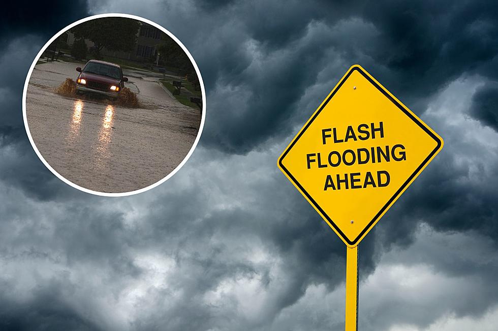
The Cheyenne Office of the National Weather Service says southeast Wyoming residents can expect heavy rain this week, possibly leading to some flash flooding.

The agency posted the following to it's website:

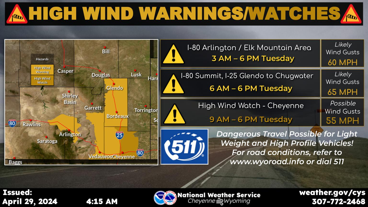
  Good news and bad news for folks in southeast Wyoming and Nebraska Panhandle, more rain is on the way! After today, rain chances really begin to ramp up, with widespread showers and thunderstorms returning Wednesday and continuing through the rest of the week. Areas that receive multiple rounds (or training) thunderstorms, there is a risk of experiencing flash flooding. A Marginal Risk for excessive rainfall has been highlighted for the southern Panhandle , west to Cheyenne and north to Scottsbluff Wednesday. This area will expand to cover most of southeast Wyoming Thursday, with widespread showers and thunderstorms. Never drive through flooded roadways. Turn around, don't drown. Stay tuned!

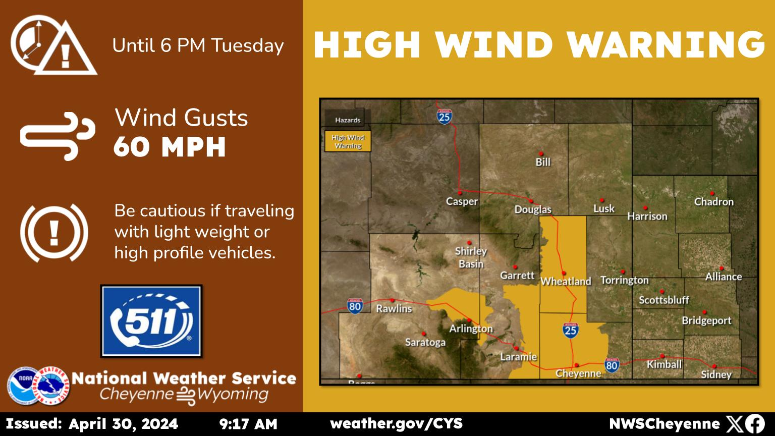
Unsettled weather expected each day this week across southeast Wyoming and Nebraska Panhandle. Low pressure currently off the coast of central California moves inland Wednesday afternoon. This low will create increasing coverage of showers and storms across the area each afternoon and evening. Need to be on the lookout for heavy rainfall that could lead to flash flooding later in the week. Stay tuned!

Here is the forecast for Cheyenne:

Today
A 50 percent chance of showers and thunderstorms, mainly after 1pm. Increasing clouds, with a high near 76. West wind 5 to 10 mph becoming south in the morning.
Tonight
A 30 percent chance of showers and thunderstorms, mainly before 9pm. Mostly cloudy, with a low around 46. West northwest wind 5 to 10 mph becoming south in the evening.
Wednesday
Showers and possibly a thunderstorm after noon. Some of the storms could be severe. High near 76. South southwest wind 5 to 10 mph becoming south 10 to 15 mph in the afternoon. Winds could gust as high as 25 mph. Chance of precipitation is 80%.
Wednesday Night
A 50 percent chance of showers and thunderstorms before midnight. Mostly cloudy, with a low around 49. South wind 10 to 15 mph becoming south southeast 5 to 10 mph after midnight. Winds could gust as high as 25 mph.
Thursday
Showers and possibly a thunderstorm after noon. High near 71. Breezy, with a south southeast wind 5 to 10 mph increasing to 15 to 20 mph in the afternoon. Chance of precipitation is 80%.
Thursday Night
Showers and thunderstorms likely before 9pm, then showers likely and possibly a thunderstorm between 9pm and midnight. Mostly cloudy, with a low around 48. Chance of precipitation is 60%.
Friday
Showers and possibly a thunderstorm. High near 67. Chance of precipitation is 80%.
Friday Night
Showers and possibly a thunderstorm before midnight, then a chance of showers. Mostly cloudy, with a low around 48.
Saturday
Showers likely, then showers and possibly a thunderstorm after noon. Mostly cloudy, with a high near 65.
Saturday Night
Showers likely and possibly a thunderstorm. Mostly cloudy, with a low around 50.
Sunday
Showers and possibly a thunderstorm. Mostly cloudy, with a high near 65.
Sunday Night
A chance of showers and thunderstorms. Mostly cloudy, with a low around 50.
Monday
Showers likely and possibly a thunderstorm. Partly sunny, with a high near 69.

Here is the Laramie forecast:

Today
A chance of showers and thunderstorms before 2pm, then showers likely and possibly a thunderstorm between 2pm and 5pm, then a chance of showers and thunderstorms after 5pm. Increasing clouds, with a high near 66. Northwest wind 5 to 15 mph becoming south southwest in the morning. Chance of precipitation is 70%. New rainfall amounts of less than a tenth of an inch, except higher amounts possible in thunderstorms.
Tonight
Partly cloudy, with a low around 43. South wind around 10 mph.
Wednesday
Showers and possibly a thunderstorm after noon. High near 65. South southeast wind 5 to 10 mph. Chance of precipitation is 90%.
Wednesday Night
A 30 percent chance of showers and thunderstorms before midnight. Mostly cloudy, with a low around 44. South southeast wind 5 to 10 mph.
Thursday
A slight chance of showers before 9am, then a slight chance of showers and thunderstorms between 9am and noon, then showers and possibly a thunderstorm after noon. High near 59. South wind 5 to 15 mph. Chance of precipitation is 100%.
Thursday Night
A 40 percent chance of showers and thunderstorms before midnight. Mostly cloudy, with a low around 43.
Friday
Showers likely, then showers and possibly a thunderstorm after noon. High near 58. Chance of precipitation is 90%.
Friday Night
Showers likely and possibly a thunderstorm before midnight, then a chance of showers. Mostly cloudy, with a low around 42.
Saturday
Showers likely, then showers and possibly a thunderstorm after noon. Mostly cloudy, with a high near 55. Breezy.
Saturday Night
Showers likely and possibly a thunderstorm before midnight, then a chance of showers. Mostly cloudy, with a low around 44.
Sunday
Showers and possibly a thunderstorm. Mostly cloudy, with a high near 56. Breezy.
Sunday Night
A chance of showers and thunderstorms. Mostly cloudy, with a low around 45. Breezy.
Monday
Showers likely and possibly a thunderstorm. Partly sunny, with a high near 60. Breezy.

Please Stop Doing These 10 Things at Walmart in Casper