The Cheyenne Office of the National Weather Service is predicting dangeroulsly cold temperatures in southeast Wyoming today, with high temperatures not cracking the zero mark.

The agency posted the following on its website: "A reinforcing shot of cold air pushed into our area overnight, leading to another bitterly cold day on Monday. It will be colder than Sunday with stronger winds also, occasionally gusting 25 to 35 MPH. Frostbite can occur in minutes at these temperatures! ❄️ Snow will taper off this morning from north to south, with some sunshine working in by the afternoon hours. Temperatures will plummet after sunset, but then may gradually warm through the night in the windier areas. Valleys and more sheltered locations can expect a brutally cold start to Tuesday with lows in the teens to 20s below zero. Wind Chill Warnings remain in effect until 11AM Tuesday!""

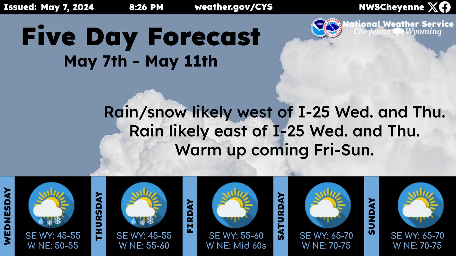
Cheyenne And Laramie Forecasts

Cheyenne Forecast

M.L.King Day
A 30 percent chance of snow, mainly before 9am. Cloudy through mid morning, then gradual clearing and cold, with a high near -4. Wind chill values between -25 and -30. North wind 10 to 15 mph.
Tonight
Mostly clear, with a temperature rising to around -2 by 5am. Wind chill values between -25 and -35. West wind 10 to 15 mph.
Tuesday
Patchy blowing snow. Mostly sunny, with a high near 26. Wind chill values between -10 and -20. Windy, with a west wind 20 to 30 mph, with gusts as high as 40 mph.
Tuesday Night
Patchy blowing snow. Partly cloudy, with a low around 19. Windy, with a west wind 20 to 30 mph, with gusts as high as 40 mph.
Wednesday
A 20 percent chance of snow after 11am. Patchy blowing snow before 8am. Partly sunny, with a high near 39. Breezy, with a west wind 15 to 20 mph, with gusts as high as 30 mph.
Wednesday Night
A 20 percent chance of snow before 11pm. Partly cloudy, with a low around 20. Breezy.
Thursday
A 30 percent chance of snow. Partly sunny, with a high near 36. Breezy.
Thursday Night
A slight chance of snow before 11pm. Mostly cloudy, with a low around 4.
Friday
Mostly sunny, with a high near 29.
Friday Night
Partly cloudy, with a low around 14.
Saturday
Partly sunny, with a high near 44.
Saturday Night
Mostly cloudy, with a low around 26.
Sunday
Mostly sunny, with a high near 46.
Laramie Forecast
M.L.King Day
A 40 percent chance of snow, mainly before 9am. Cloudy through mid morning, then gradual clearing and cold, with a high near -8. Wind chill values between -30 and -35. North wind 10 to 15 mph becoming west northwest in the afternoon.
Tonight
Patchy blowing snow after 10pm. Mostly clear, with a temperature rising to around -3 by 5am. Wind chill values between -30 and -40. Breezy, with a west wind 15 to 25 mph, with gusts as high as 35 mph.
Tuesday
Widespread blowing snow, mainly between 8am and 11am. Mostly sunny, with a high near 21. Wind chill values between -15 and -25. Windy, with a west wind 30 to 35 mph, with gusts as high as 45 mph.
Tuesday Night
Patchy blowing snow. Partly cloudy, with a low around 20. Wind chill values between zero and 10. Windy, with a west wind 30 to 40 mph, with gusts as high as 55 mph.
Wednesday
A 40 percent chance of snow. Patchy blowing snow. Mostly sunny, with a high near 34. Windy, with a west wind 30 to 35 mph, with gusts as high as 50 mph.
Wednesday Night
A 30 percent chance of snow. Patchy blowing snow. Partly cloudy, with a low around 24. Windy.
Thursday
A 50 percent chance of snow. Patchy blowing snow. Partly sunny, with a high near 31. Windy.
Thursday Night
A chance of snow before 11pm. Patchy blowing snow before 8pm. Mostly cloudy, with a low around 13.
Friday
Mostly sunny, with a high near 31.
Friday Night
Mostly cloudy, with a low around 22.
Saturday
Mostly sunny, with a high near 40. Breezy.
Saturday Night
Mostly cloudy, with a low around 30. Breezy.
Sunday
Mostly sunny, with a high near 40. Breezy.

Backroad Up The Bighorns

There are many ways to explore the Bighorn Mountain.

Not all of the backroads are dangerous.

Some are of good quality, and have the best views you'll ever see.

Gallery Credit: Glenn Woods