The Cheyenne Office of the National Weather Service has updated its forecast for a major winter storm that is expected to blast southeast Wyoming and the Nebraska Panhandle starting today and going into Wednesday.

The agency issued an update at 8 am on Monday which includes the following:


Key Messages ➔ Blizzard Warnings in effect for the Nebraska panhandle and portions of southeast Wyoming.

◆ Snow accumulations between 6 and 12 inches for Platte, Goshen, east Laramie, south Sioux, Box Butte, Scotts Bluff, Morrill, Banner, Kimball, and Cheyenne counties. Locally higher accumulations possible.

◆ Snow accumulations of 12 to 16 inches for Converse, Niobrara, north Sioux, and Dawes counties. Locally higher accumulations possible around Chadron.

◆ Wind gusts 50 to 60 MPH. ➔ Winter Storm Warnings in effect for portions of southeast Wyoming.

◆ Snow accumulations between 1 and 2 feet for the Snowy and Sierra Madre Ranges.

◆ Snow accumulations between 8 and 12 inches for Carbon County. ➔ Winter Weather Advisories in effect for Cheyenne, Laramie and north Laramie Range.

Snow accumulations of 4 to 5 inches for the Laramie and Cheyenne.

◆ Snow accumulations of 8 to 12 inches for the north Laramie

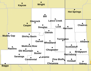
The agency also posted the following map. The bright orange is the area for which a blizzard warning has been issued. The light blue, which at last report includes both Laramie and Cheyenne, is under a less-severe winter weather advisory. The Pink area is under a winter storm warning:

Map of Forecast Area

Here is the forecast for Cheyenne:

Today
A 10 percent chance of snow after 5pm. Mostly cloudy, with a high near 43. North northeast wind 5 to 15 mph.
Tonight
Snow likely, mainly after 11pm. Patchy blowing snow after 3am. Cloudy, with a low around 12. Wind chill values between -5 and 5. Windy, with a north northwest wind 20 to 30 mph, with gusts as high as 40 mph. Chance of precipitation is 70%. New snow accumulation of 1 to 3 inches possible.
Tuesday
Snow. Widespread blowing snow, mainly after 10am. High near 20. Wind chill values between -10 and zero. Windy, with a northwest wind 35 to 40 mph, with gusts as high as 60 mph. Chance of precipitation is 80%. New snow accumulation of 1 to 2 inches possible.
Tuesday Night
Snow likely, mainly before 11pm. Areas of blowing snow. Mostly cloudy, with a low around 15. Wind chill values between -5 and zero. Windy, with a northwest wind 30 to 35 mph, with gusts as high as 55 mph. Chance of precipitation is 60%. New snow accumulation of less than a half inch possible.
Wednesday
A 40 percent chance of snow, mainly before 11am. Widespread blowing snow, mainly before 3pm. Mostly cloudy, with a high near 25. Windy, with a northwest wind 30 to 35 mph, with gusts as high as 50 mph.
Wednesday Night
Patchy blowing snow. Mostly cloudy, with a low around 15. Blustery.
Thursday
Patchy blowing snow. Mostly sunny, with a high near 25. Blustery.
Thursday Night
Patchy blowing snow. Partly cloudy, with a low around 9. Blustery.
Friday
Patchy blowing snow. Mostly sunny, with a high near 21. Blustery.
Friday Night
Patchy blowing snow before 10pm. Mostly clear, with a low around 4. Blustery.
Saturday
Mostly sunny, with a high near 24. Breezy.
Saturday Night
Partly cloudy, with a low around 4.
Sunday
Mostly sunny, with a high near 24.
Here is the Laramie Forecast
Today
Mostly cloudy, with a temperature rising to near 39 by 11am, then falling to around 29 during the remainder of the day. West wind 10 to 15 mph becoming east northeast in the afternoon.
Tonight
Snow, mainly after 11pm. Patchy blowing snow before 10pm, then patchy blowing snow after 3am. Low around 10. Wind chill values between -10 and zero. Blustery, with a north wind 10 to 15 mph becoming west northwest 20 to 25 mph after midnight. Chance of precipitation is 90%. New snow accumulation of 2 to 4 inches possible.
Tuesday
Snow. Widespread blowing snow. Steady temperature around 12. Wind chill values between -10 and -15. Windy, with a west northwest wind 30 to 35 mph, with gusts as high as 55 mph. Chance of precipitation is 90%. New snow accumulation of 2 to 4 inches possible.
Tuesday Night
Snow. Widespread blowing snow. Low around 14. Wind chill values between -10 and zero. Windy, with a west northwest wind 30 to 35 mph, with gusts as high as 55 mph. Chance of precipitation is 90%. New snow accumulation of around an inch possible.
Wednesday
Snow. Widespread blowing snow. High near 20. Windy, with a west northwest wind 30 to 35 mph, with gusts as high as 45 mph. Chance of precipitation is 80%.
Wednesday Night
A 40 percent chance of snow. Widespread blowing snow, mainly before 11pm. Mostly cloudy, with a low around 13. Windy.
Thursday
A 20 percent chance of snow before 11am. Patchy blowing snow. Partly sunny, with a high near 17. Blustery.
Thursday Night
Patchy blowing snow. Mostly cloudy, with a low around 7. Blustery.
Friday
Patchy blowing snow. Partly sunny, with a high near 13. Blustery.
Friday Night
Patchy blowing snow. Partly cloudy, with a low around 2. Blustery.
Saturday
Mostly sunny, with a high near 15. Breezy.
Saturday Night
Partly cloudy, with a low around 3. Breezy.
Sunday
Mostly sunny, with a high near 18.

9 Celebrities Who Are Jerks and 19 Who Are Awesome, According to You

We asked. You answered. Northern Coloradans have met a lot of famous people, some of whom were nice and some of whom were...not so nice. Read on to see some of your most memorable celebrity encounters.